Michigan County Map
Labeled county boundary map and complete directory of all 83 counties in Michigan (MI, State FIPS 26). View 5-digit FIPS codes, county seats, land area in square miles, and official county government websites below.
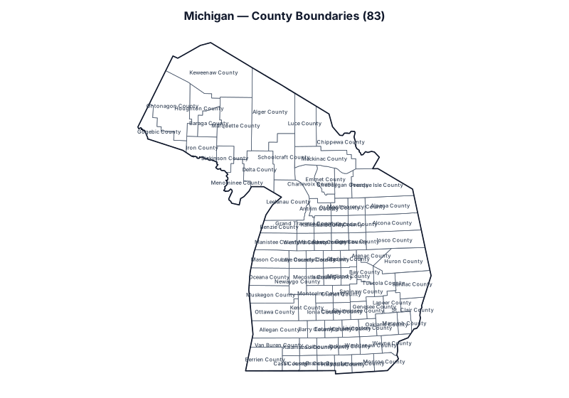
Showing all 83 counties in Michigan. Use the search box below to filter by county name, 5-digit FIPS code, or county seat.
Michigan County Statistics & Summary
Total Counties
83
Largest by Land Area
Marquette County
Smallest by Land Area
Benzie County
All 83 Counties in Michigan (FIPS, County Seat & Official Website)
| County Name | 5-Digit FIPS | Seat / Administrative Center | Land Area (sq mi) | Coordinates | Official Website |
|---|---|---|---|---|---|
| Alcona County | 26001 | Harrisville | 674.7 | 44.657°, -83.295° | Official Site |
| Alger County | 26003 | Munising | 915 | 46.522°, -86.657° | Official Site |
| Allegan County | 26005 | Allegan | 825.4 | 42.421°, -86.261° | Official Site |
| Alpena County | 26007 | Alpena | 571.9 | 44.895°, -83.427° | Official Site |
| Antrim County | 26009 | Bellaire | 475.7 | 45.005°, -85.164° | Official Site |
| Arenac County | 26011 | Standish | 363.2 | 44.037°, -83.741° | Official Site |
| Baraga County | 26013 | L'Anse | 898.4 | 46.696°, -88.362° | Official Site |
| Barry County | 26015 | Hastings | 553.1 | 42.583°, -85.315° | Official Site |
| Bay County | 26017 | Bay City | 442.4 | 43.700°, -83.979° | Official Site |
| Benzie County | 26019 | Beulah | 319.7 | 44.637°, -86.232° | Official Site |
| Berrien County | 26021 | St. Joseph | 567.8 | 41.791°, -86.743° | Official Site |
| Branch County | 26023 | Coldwater | 506.4 | 41.919°, -85.067° | Official Site |
| Calhoun County | 26025 | Marshall | 706.3 | 42.243°, -85.012° | Official Site |
| Cass County | 26027 | Cassopolis | 490.1 | 41.917°, -86.000° | Official Site |
| Charlevoix County | 26029 | Charlevoix | 416.3 | 45.619°, -85.544° | Official Site |
| Cheboygan County | 26031 | Cheboygan | 715.3 | 45.476°, -84.495° | Official Site |
| Chippewa County | 26033 | Sault Ste. Marie | 1,558.5 | 46.322°, -84.521° | Official Site |
| Clare County | 26035 | Harrison | 564.4 | 43.991°, -84.838° | Official Site |
| Clinton County | 26037 | St. Johns | 567.3 | 42.950°, -84.592° | Official Site |
| Crawford County | 26039 | Grayling | 556.4 | 44.678°, -84.612° | Official Site |
| Delta County | 26041 | Escanaba | 1,171.1 | 45.805°, -86.902° | Official Site |
| Dickinson County | 26043 | Iron Mountain | 761 | 46.013°, -87.866° | Official Site |
| Eaton County | 26045 | Charlotte | 575.2 | 42.590°, -84.846° | Official Site |
| Emmet County | 26047 | Petoskey | 467.5 | 45.590°, -84.987° | Official Site |
| Genesee County | 26049 | Flint | 636.9 | 43.021°, -83.706° | Official Site |
| Gladwin County | 26051 | Gladwin | 501.8 | 43.990°, -84.390° | Official Site |
| Gogebic County | 26053 | Bessemer | 1,102.1 | 46.488°, -89.788° | Official Site |
| Grand Traverse County | 26055 | Traverse City | 464.3 | 44.719°, -85.554° | Official Site |
| Gratiot County | 26057 | Ithaca | 568.4 | 43.292°, -84.605° | Official Site |
| Hillsdale County | 26059 | Hillsdale | 598.2 | 41.928°, -84.638° | Official Site |
| Houghton County | 26061 | Houghton | 1,009.1 | 46.998°, -88.652° | Official Site |
| Huron County | 26063 | Bad Axe | 835.9 | 43.908°, -82.857° | Official Site |
| Ingham County | 26065 | Mason | 556.1 | 42.603°, -84.374° | Official Site |
| Ionia County | 26067 | Ionia | 571.3 | 42.945°, -85.074° | Official Site |
| Iosco County | 26069 | Tawas City | 549.5 | 44.387°, -83.380° | Official Site |
| Iron County | 26071 | Crystal Falls | 1,166.1 | 46.178°, -88.552° | Official Site |
| Isabella County | 26073 | Mount Pleasant | 572.7 | 43.645°, -84.839° | Official Site |
| Jackson County | 26075 | Jackson | 701.9 | 42.248°, -84.421° | Official Site |
| Kalamazoo County | 26077 | Kalamazoo | 562 | 42.246°, -85.533° | Official Site |
| Kalkaska County | 26079 | Kalkaska | 559.7 | 44.678°, -85.089° | Official Site |
| Kent County | 26081 | Grand Rapids | 849.5 | 43.032°, -85.547° | Official Site |
| Keweenaw County | 26083 | Eagle River | 540.1 | 47.367°, -88.351° | Official Site |
| Lake County | 26085 | Baldwin | 567.6 | 43.995°, -85.811° | Official Site |
| Lapeer County | 26087 | Lapeer | 647.5 | 43.089°, -83.224° | Official Site |
| Leelanau County | 26089 | Suttons Bay Township | 347.2 | 45.146°, -86.052° | Official Site |
| Lenawee County | 26091 | Adrian | 749.7 | 41.896°, -84.074° | Official Site |
| Livingston County | 26093 | Howell | 565.3 | 42.602°, -83.912° | Official Site |
| Luce County | 26095 | Newberry | 899.1 | 46.511°, -85.518° | Official Site |
| Mackinac County | 26097 | St. Ignace | 1,021.9 | 46.168°, -85.304° | Official Site |
| Macomb County | 26099 | Mount Clemens | 479.4 | 42.672°, -82.912° | Official Site |
| Manistee County | 26101 | Manistee | 542.3 | 44.245°, -86.328° | Official Site |
| Marquette County | 26103 | Marquette | 1,809.1 | 46.632°, -87.563° | Official Site |
| Mason County | 26105 | Ludington | 495 | 43.957°, -86.443° | Official Site |
| Mecosta County | 26107 | Big Rapids | 555.2 | 43.635°, -85.333° | Official Site |
| Menominee County | 26109 | Menominee | 1,044 | 45.536°, -87.501° | Official Site |
| Midland County | 26111 | Midland | 518.4 | 43.648°, -84.379° | Official Site |
| Missaukee County | 26113 | Lake City | 564.8 | 44.325°, -85.085° | Official Site |
| Monroe County | 26115 | Monroe | 549.4 | 41.916°, -83.487° | Official Site |
| Montcalm County | 26117 | Stanton | 705.3 | 43.313°, -85.150° | Official Site |
| Montmorency County | 26119 | Atlanta | 546.7 | 45.024°, -84.130° | Official Site |
| Muskegon County | 26121 | Muskegon | 503.9 | 43.429°, -86.421° | Official Site |
| Newaygo County | 26123 | White Cloud | 838.9 | 43.563°, -85.791° | Official Site |
| Oakland County | 26125 | Pontiac | 867.4 | 42.660°, -83.384° | Official Site |
| Oceana County | 26127 | Hart | 538.1 | 43.604°, -86.467° | Official Site |
| Ogemaw County | 26129 | West Branch | 563.5 | 44.333°, -84.128° | Official Site |
| Ontonagon County | 26131 | Ontonagon | 1,311 | 46.835°, -89.277° | Official Site |
| Osceola County | 26133 | Reed City | 566.3 | 43.997°, -85.318° | Official Site |
| Oscoda County | 26135 | Mio | 565.7 | 44.687°, -84.127° | Official Site |
| Otsego County | 26137 | Gaylord | 515 | 45.022°, -84.577° | Official Site |
| Ottawa County | 26139 | Grand Haven | 563.5 | 43.055°, -86.219° | Official Site |
| Presque Isle County | 26141 | Rogers City | 658.7 | 45.252°, -83.432° | Official Site |
| Roscommon County | 26143 | Roscommon | 519.9 | 44.340°, -84.611° | Official Site |
| Saginaw County | 26145 | Saginaw | 800.8 | 43.328°, -84.055° | Official Site |
| Sanilac County | 26151 | Sandusky | 962.6 | 43.449°, -82.643° | Official Site |
| Schoolcraft County | 26153 | Manistique | 1,171.9 | 45.986°, -86.218° | Official Site |
| Shiawassee County | 26155 | Corunna | 531.1 | 42.952°, -84.146° | Official Site |
| St. Clair County | 26147 | Port Huron | 721.5 | 42.929°, -82.669° | Official Site |
| St. Joseph County | 26149 | Centreville | 500.6 | 41.911°, -85.523° | Official Site |
| Tuscola County | 26157 | Caro | 804.9 | 43.488°, -83.437° | Official Site |
| Van Buren County | 26159 | Paw Paw | 607.8 | 42.282°, -86.306° | Official Site |
| Washtenaw County | 26161 | Ann Arbor | 706 | 42.252°, -83.843° | Official Site |
| Wayne County | 26163 | Detroit | 611.8 | 42.285°, -83.262° | Official Site |
| Wexford County | 26165 | Cadillac | 564.9 | 44.331°, -85.570° | Official Site |
How Michigan Counties and 5-Digit FIPS Codes Work
In U.S. Census Bureau TIGER/Line geography, Michigan (MI) is assigned the 2-digit state Federal Information Processing Series (FIPS) code 26 and covers 56,613 square miles of land area across 83 counties in the Eastern Time (ET); four Upper Peninsula counties bordering Wisconsin are in Central Time (CT) zone (with Lansing as the state capital). Every county in the directory above carries a unique 5-digit GEOID formed by combining state prefix 26 with a 3-digit county code (ranging alphabetically from Alcona County at 26001 to Wexford County at 26165).
Because U.S. Postal Service 5-digit ZIP Codes follow mail carrier delivery routes rather than local government borders, many postal addresses in Michigan carry a neighboring city’s mailing name or sit inside a multi-county ZIP Code Tabulation Area (ZCTA). Property tax assessments, deed recording, circuit and county court venue, voter registration precincts, sheriff jurisdiction, and county sales tax rates in Michigan are determined by the legal county boundary shown on the map above rather than the postal city name on an envelope.
Land area figures in square miles and internal centroid coordinates (INTPTLAT, INTPTLON) come directly from the U.S. Census Bureau’s current TIGERweb State_County benchmark, while 83 administrative seats and 83 verified official government websites are cross-referenced from Wikidata (CC0). Need a clean outline worksheet without county labels, or want to verify which Michigan county a specific home or business address sits in? Open the Blank Map of Michigan, run a street-segment check on Address to County Lookup, check multi-county postal overlap on ZIP Code to County Lookup, or browse all 50 states on the National U.S. County Map.
Adjacent State County Maps
Explore county maps and FIPS directories for states bordering Michigan: