U.S. County Map
Explore all 3,144 U.S. counties and county-equivalent jurisdictions (Louisiana parishes, Alaska boroughs and census areas, Connecticut planning regions, independent cities, and the District of Columbia) across the 50 states and D.C. Download or print the national county boundary map or open any state directory below.
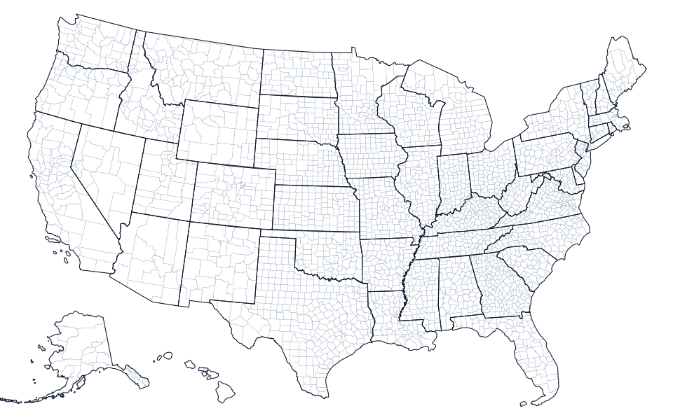
Showing all 3,144 U.S. county boundaries with state borders overlaid. Select a state below to view its labeled county map, 5-digit FIPS codes, and county seats.
U.S. County Maps and FIPS Directories by State (50 States + D.C.)
Choose a state to open its printable county boundary map and complete table of counties, FIPS codes, county seats, land area, and official websites:
| State | FIPS | Counties / Equivalents | Land Area (sq mi) | Largest County / Equivalent | Maps |
|---|---|---|---|---|---|
| Alabama (AL) | 01 | 67 Counties | 50,652 | Baldwin County (1,589.9 sq mi) | County Map · Blank Map |
| Alaska (AK) | 02 | 30 Boroughs and Census Areas | 571,409 | Yukon-Koyukuk Census Area (145,767.5 sq mi) | County Map · Blank Map |
| Arizona (AZ) | 04 | 15 Counties | 113,656 | Coconino County (18,616.4 sq mi) | County Map · Blank Map |
| Arkansas (AR) | 05 | 75 Counties | 51,992 | Union County (1,039.1 sq mi) | County Map · Blank Map |
| California (CA) | 06 | 58 Counties | 155,860 | San Bernardino County (20,068.4 sq mi) | County Map · Blank Map |
| Colorado (CO) | 08 | 64 Counties | 103,637 | Las Animas County (4,772.9 sq mi) | County Map · Blank Map |
| Connecticut (CT) | 09 | 9 Planning Regions | 4,843 | Capitol Planning Region (1,027.4 sq mi) | County Map · Blank Map |
| Delaware (DE) | 10 | 3 Counties | 1,949 | Sussex County (936.2 sq mi) | County Map · Blank Map |
| District of Columbia (DC) | 11 | 1 County Equivalent | 61 | District of Columbia (61.1 sq mi) | County Map · Blank Map |
| Florida (FL) | 12 | 67 Counties | 53,658 | Collier County (1,997 sq mi) | County Map · Blank Map |
| Georgia (GA) | 13 | 159 Counties | 57,718 | Ware County (899.4 sq mi) | County Map · Blank Map |
| Hawaii (HI) | 15 | 5 Counties | 6,423 | Hawaii County (4,028.4 sq mi) | County Map · Blank Map |
| Idaho (ID) | 16 | 44 Counties | 82,645 | Idaho County (8,477.5 sq mi) | County Map · Blank Map |
| Illinois (IL) | 17 | 102 Counties | 55,514 | McLean County (1,183.2 sq mi) | County Map · Blank Map |
| Indiana (IN) | 18 | 92 Counties | 35,825 | Allen County (657.1 sq mi) | County Map · Blank Map |
| Iowa (IA) | 19 | 99 Counties | 55,854 | Kossuth County (972.7 sq mi) | County Map · Blank Map |
| Kansas (KS) | 20 | 105 Counties | 81,759 | Butler County (1,429.7 sq mi) | County Map · Blank Map |
| Kentucky (KY) | 21 | 120 Counties | 39,486 | Pike County (786.2 sq mi) | County Map · Blank Map |
| Louisiana (LA) | 22 | 64 Parishes | 43,221 | Vernon Parish (1,326.7 sq mi) | County Map · Blank Map |
| Maine (ME) | 23 | 16 Counties | 30,845 | Aroostook County (6,671.2 sq mi) | County Map · Blank Map |
| Maryland (MD) | 24 | 24 Counties and Independent City | 9,711 | Frederick County (660.7 sq mi) | County Map · Blank Map |
| Massachusetts (MA) | 25 | 14 Counties | 7,801 | Worcester County (1,510.7 sq mi) | County Map · Blank Map |
| Michigan (MI) | 26 | 83 Counties | 56,613 | Marquette County (1,809.1 sq mi) | County Map · Blank Map |
| Minnesota (MN) | 27 | 87 Counties | 79,632 | St. Louis County (6,248.1 sq mi) | County Map · Blank Map |
| Mississippi (MS) | 28 | 82 Counties | 46,925 | Yazoo County (922.3 sq mi) | County Map · Blank Map |
| Missouri (MO) | 29 | 115 Counties and Independent City | 68,747 | Texas County (1,177.3 sq mi) | County Map · Blank Map |
| Montana (MT) | 30 | 56 Counties | 145,550 | Beaverhead County (5,542.7 sq mi) | County Map · Blank Map |
| Nebraska (NE) | 31 | 93 Counties | 76,815 | Cherry County (5,960.1 sq mi) | County Map · Blank Map |
| Nevada (NV) | 32 | 17 Counties and Independent City | 109,860 | Nye County (18,181.9 sq mi) | County Map · Blank Map |
| New Hampshire (NH) | 33 | 10 Counties | 8,954 | Coos County (1,794.6 sq mi) | County Map · Blank Map |
| New Jersey (NJ) | 34 | 21 Counties | 7,355 | Burlington County (799.3 sq mi) | County Map · Blank Map |
| New Mexico (NM) | 35 | 33 Counties | 121,313 | Catron County (6,924.2 sq mi) | County Map · Blank Map |
| New York (NY) | 36 | 62 Counties | 47,123 | St. Lawrence County (2,679.5 sq mi) | County Map · Blank Map |
| North Carolina (NC) | 37 | 100 Counties | 48,624 | Robeson County (947.3 sq mi) | County Map · Blank Map |
| North Dakota (ND) | 38 | 53 Counties | 68,994 | McKenzie County (2,760.1 sq mi) | County Map · Blank Map |
| Ohio (OH) | 39 | 88 Counties | 40,859 | Ashtabula County (702.4 sq mi) | County Map · Blank Map |
| Oklahoma (OK) | 40 | 77 Counties | 68,597 | Osage County (2,246.7 sq mi) | County Map · Blank Map |
| Oregon (OR) | 41 | 36 Counties | 95,997 | Harney County (10,134.5 sq mi) | County Map · Blank Map |
| Pennsylvania (PA) | 42 | 67 Counties | 44,742 | Lycoming County (1,228.9 sq mi) | County Map · Blank Map |
| Rhode Island (RI) | 44 | 5 Counties | 1,034 | Providence County (409.5 sq mi) | County Map · Blank Map |
| South Carolina (SC) | 45 | 46 Counties | 30,064 | Horry County (1,133.1 sq mi) | County Map · Blank Map |
| South Dakota (SD) | 46 | 66 Counties | 75,809 | Meade County (3,470.9 sq mi) | County Map · Blank Map |
| Tennessee (TN) | 47 | 95 Counties | 41,225 | Shelby County (752.8 sq mi) | County Map · Blank Map |
| Texas (TX) | 48 | 254 Counties | 261,259 | Brewster County (6,183.8 sq mi) | County Map · Blank Map |
| Utah (UT) | 49 | 29 Counties | 82,596 | San Juan County (7,823.7 sq mi) | County Map · Blank Map |
| Vermont (VT) | 50 | 14 Counties | 9,217 | Windsor County (969.1 sq mi) | County Map · Blank Map |
| Virginia (VA) | 51 | 133 Counties and Independent Cities | 39,481 | Pittsylvania County (969 sq mi) | County Map · Blank Map |
| Washington (WA) | 53 | 39 Counties | 66,457 | Okanogan County (5,266.2 sq mi) | County Map · Blank Map |
| West Virginia (WV) | 54 | 55 Counties | 24,041 | Randolph County (1,039.7 sq mi) | County Map · Blank Map |
| Wisconsin (WI) | 55 | 72 Counties | 54,168 | Marathon County (1,545.2 sq mi) | County Map · Blank Map |
| Wyoming (WY) | 56 | 23 Counties | 97,089 | Sweetwater County (10,427 sq mi) | County Map · Blank Map |
How U.S. Counties and County-Equivalent Jurisdictions Work
In U.S. Census Bureau TIGER/Line geography, the 50 states and the District of Columbia are partitioned into 3,144 primary county-level subdivisions, each identified by a unique 5-digit Federal Information Processing Series (FIPS) code that combines the 2-digit state FIPS code with a 3-digit county code. The national map above renders every county boundary from the U.S. Census Bureau’s cartographic boundary files in an Albers Equal-Area Conic projection.
Parishes, Boroughs, Planning Regions, and Independent Cities
While 46 states divide their territory into standard counties, several states use distinct legal county equivalents that carry full 5-digit FIPS codes in federal datasets:
- Louisiana (64 Parishes): Louisiana’s primary local government units are called parishes rather than counties.
- Alaska (30 Boroughs and Census Areas): Alaska is divided into 20 organized boroughs (including consolidated city-boroughs such as Anchorage, Juneau, and Sitka) and 10 Unorganized Borough census areas delineated for statistical governance.
- Connecticut (9 Planning Regions): Effective with the 2022–2024 Census TIGER/Line transition, Connecticut’s nine Council of Governments (COG) Planning Regions replaced its eight historic counties as county-equivalent entities (
09110through09190). - 41 Independent Cities and Washington, D.C.: Virginia has 38 independent cities that are legally separate from any surrounding county, alongside Baltimore City (Maryland), St. Louis City (Missouri), and Carson City (Nevada), plus the District of Columbia (
11001).
County Extremes and Live County Lookups
Texas has the most counties of any state (254), followed by Georgia (159) and Virginia (133 total: 95 counties and 38 independent cities), while Delaware has the fewest counties (3). Want to check which county you are in right now or look up a specific address or ZIP Code? Use What County Am I In?, Address to County Lookup, or ZIP Code to County Lookup.