Wisconsin County Map
Labeled county boundary map and complete directory of all 72 counties in Wisconsin (WI, State FIPS 55). View 5-digit FIPS codes, county seats, land area in square miles, and official county government websites below.
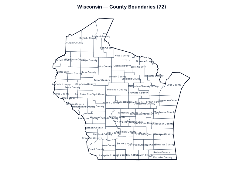
Showing all 72 counties in Wisconsin. Use the search box below to filter by county name, 5-digit FIPS code, or county seat.
Wisconsin County Statistics & Summary
Total Counties
72
Largest by Land Area
Marathon County
Smallest by Land Area
Pepin County
All 72 Counties in Wisconsin (FIPS, County Seat & Official Website)
| County Name | 5-Digit FIPS | Seat / Administrative Center | Land Area (sq mi) | Coordinates | Official Website |
|---|---|---|---|---|---|
| Adams County | 55001 | Friendship | 645.6 | 43.974°, -89.767° | Official Site |
| Ashland County | 55003 | Ashland | 1,045 | 46.544°, -90.680° | Official Site |
| Barron County | 55005 | Barron | 863.1 | 45.437°, -91.853° | Official Site |
| Bayfield County | 55007 | Washburn | 1,477.9 | 46.634°, -91.177° | Official Site |
| Brown County | 55009 | Green Bay | 530.1 | 44.474°, -87.996° | Official Site |
| Buffalo County | 55011 | Alma | 675.8 | 44.386°, -91.761° | Official Site |
| Burnett County | 55013 | Siren | 821.6 | 45.867°, -92.376° | Official Site |
| Calumet County | 55015 | Chilton | 318.2 | 44.078°, -88.212° | Official Site |
| Chippewa County | 55017 | Chippewa Falls | 1,008.4 | 45.069°, -91.284° | Official Site |
| Clark County | 55019 | Neillsville | 1,209.7 | 44.739°, -90.610° | Official Site |
| Columbia County | 55021 | Portage | 765.6 | 43.472°, -89.331° | Official Site |
| Crawford County | 55023 | Prairie du Chien | 570.8 | 43.243°, -90.935° | Official Site |
| Dane County | 55025 | Madison | 1,196.5 | 43.068°, -89.418° | Official Site |
| Dodge County | 55027 | Juneau | 875.7 | 43.430°, -88.702° | Official Site |
| Door County | 55029 | Sturgeon Bay | 481.9 | 45.093°, -87.049° | Official Site |
| Douglas County | 55031 | Superior | 1,304.3 | 46.463°, -91.892° | Official Site |
| Dunn County | 55033 | Menomonie | 850.2 | 44.948°, -91.898° | Official Site |
| Eau Claire County | 55035 | Eau Claire | 637.9 | 44.726°, -91.286° | Official Site |
| Florence County | 55037 | Florence | 488 | 45.872°, -88.407° | Official Site |
| Fond du Lac County | 55039 | Fond du Lac | 719.6 | 43.755°, -88.493° | Official Site |
| Forest County | 55041 | Crandon | 1,014.3 | 45.667°, -88.773° | Official Site |
| Grant County | 55043 | Lancaster | 1,147.6 | 42.870°, -90.694° | Official Site |
| Green County | 55045 | Monroe | 584 | 42.675°, -89.605° | Official Site |
| Green Lake County | 55047 | Green Lake | 349.5 | 43.780°, -88.970° | Official Site |
| Iowa County | 55049 | Dodgeville | 762.7 | 43.001°, -90.134° | Official Site |
| Iron County | 55051 | Hurley | 758.2 | 46.327°, -90.261° | Official Site |
| Jackson County | 55053 | Black River Falls | 987.9 | 44.325°, -90.800° | Official Site |
| Jefferson County | 55055 | Jefferson | 556.5 | 43.014°, -88.774° | Official Site |
| Juneau County | 55057 | Mauston | 767.1 | 43.933°, -90.114° | Official Site |
| Kenosha County | 55059 | Kenosha | 271.8 | 42.587°, -87.880° | Official Site |
| Kewaunee County | 55061 | Kewaunee | 342.5 | 44.606°, -87.448° | Official Site |
| La Crosse County | 55063 | La Crosse | 451.8 | 43.908°, -91.112° | Official Site |
| Lafayette County | 55065 | Darlington | 633.6 | 42.659°, -90.130° | Official Site |
| Langlade County | 55067 | Antigo | 870.7 | 45.255°, -89.067° | Official Site |
| Lincoln County | 55069 | Merrill | 878.8 | 45.333°, -89.732° | Official Site |
| Manitowoc County | 55071 | Manitowoc | 589.3 | 44.156°, -87.577° | Official Site |
| Marathon County | 55073 | Wausau | 1,545.2 | 44.898°, -89.758° | Official Site |
| Marinette County | 55075 | Marinette | 1,399.5 | 45.347°, -87.991° | Official Site |
| Marquette County | 55077 | Montello | 455.7 | 43.826°, -89.409° | Official Site |
| Menominee County | 55078 | Keshena | 357.6 | 44.991°, -88.669° | Official Site |
| Milwaukee County | 55079 | Milwaukee | 241.5 | 42.913°, -87.862° | Official Site |
| Monroe County | 55081 | Sparta | 900.9 | 43.945°, -90.620° | Official Site |
| Oconto County | 55083 | Oconto | 997.5 | 44.997°, -88.207° | Official Site |
| Oneida County | 55085 | Rhinelander | 1,113.9 | 45.716°, -89.534° | Official Site |
| Outagamie County | 55087 | Appleton | 637.6 | 44.418°, -88.465° | Official Site |
| Ozaukee County | 55089 | Port Washington | 233 | 43.502°, -87.848° | Official Site |
| Pepin County | 55091 | Durand | 232 | 44.627°, -91.835° | Official Site |
| Pierce County | 55093 | Ellsworth | 574 | 44.725°, -92.426° | Official Site |
| Polk County | 55095 | Balsam Lake | 914.3 | 45.469°, -92.454° | Official Site |
| Portage County | 55097 | Stevens Point | 800.9 | 44.476°, -89.498° | Official Site |
| Price County | 55099 | Phillips | 1,254.1 | 45.679°, -90.360° | Official Site |
| Racine County | 55101 | Racine | 332.6 | 42.780°, -87.772° | Official Site |
| Richland County | 55103 | Richland Center | 586.1 | 43.376°, -90.436° | Official Site |
| Rock County | 55105 | Janesville | 718.2 | 42.670°, -89.075° | Official Site |
| Rusk County | 55107 | Ladysmith | 913.5 | 45.473°, -91.137° | Official Site |
| Sauk County | 55111 | Baraboo | 831.6 | 43.428°, -89.943° | Official Site |
| Sawyer County | 55113 | Hayward | 1,257.6 | 45.865°, -91.147° | Official Site |
| Shawano County | 55115 | Shawano | 893.2 | 44.790°, -88.756° | Official Site |
| Sheboygan County | 55117 | Sheboygan | 511.5 | 43.739°, -87.731° | Official Site |
| St. Croix County | 55109 | Hudson | 722.2 | 45.029°, -92.447° | Official Site |
| Taylor County | 55119 | Medford | 975.1 | 45.212°, -90.505° | Official Site |
| Trempealeau County | 55121 | Whitehall | 733 | 44.303°, -91.359° | Official Site |
| Vernon County | 55123 | Viroqua | 791.6 | 43.596°, -90.817° | Official Site |
| Vilas County | 55125 | Eagle River | 857.7 | 46.050°, -89.501° | Official Site |
| Walworth County | 55127 | Elkhorn | 555.4 | 42.668°, -88.542° | Official Site |
| Washburn County | 55129 | Shell Lake | 797.1 | 45.892°, -91.796° | Official Site |
| Washington County | 55131 | West Bend | 430.6 | 43.391°, -88.233° | Official Site |
| Waukesha County | 55133 | Waukesha | 549.7 | 43.018°, -88.300° | Official Site |
| Waupaca County | 55135 | Waupaca | 747.7 | 44.478°, -88.967° | Official Site |
| Waushara County | 55137 | Wautoma | 626.2 | 44.113°, -89.240° | Official Site |
| Winnebago County | 55139 | Oshkosh | 434.7 | 44.086°, -88.668° | Official Site |
| Wood County | 55141 | Wisconsin Rapids | 793 | 44.461°, -90.039° | Official Site |
How Wisconsin Counties and 5-Digit FIPS Codes Work
In U.S. Census Bureau TIGER/Line geography, Wisconsin (WI) is assigned the 2-digit state Federal Information Processing Series (FIPS) code 55 and covers 54,168 square miles of land area across 72 counties in the Central Time (CT) zone (with Madison as the state capital). Every county in the directory above carries a unique 5-digit GEOID formed by combining state prefix 55 with a 3-digit county code (ranging alphabetically from Adams County at 55001 to Wood County at 55141).
Because U.S. Postal Service 5-digit ZIP Codes follow mail carrier delivery routes rather than local government borders, many postal addresses in Wisconsin carry a neighboring city’s mailing name or sit inside a multi-county ZIP Code Tabulation Area (ZCTA). Property tax assessments, deed recording, circuit and county court venue, voter registration precincts, sheriff jurisdiction, and county sales tax rates in Wisconsin are determined by the legal county boundary shown on the map above rather than the postal city name on an envelope.
Land area figures in square miles and internal centroid coordinates (INTPTLAT, INTPTLON) come directly from the U.S. Census Bureau’s current TIGERweb State_County benchmark, while 72 administrative seats and 72 verified official government websites are cross-referenced from Wikidata (CC0). Need a clean outline worksheet without county labels, or want to verify which Wisconsin county a specific home or business address sits in? Open the Blank Map of Wisconsin, run a street-segment check on Address to County Lookup, check multi-county postal overlap on ZIP Code to County Lookup, or browse all 50 states on the National U.S. County Map.
Adjacent State County Maps
Explore county maps and FIPS directories for states bordering Wisconsin: